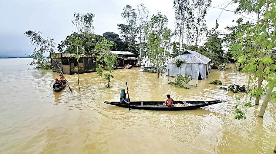
The northeastern region of Bangladesh has already faced three floods this year. The third spell of the heaviest flood devastated Sylhet region and lasted for several days last June.
The record-breaking flood especially hit Sylhet and Sunamganj districts and it prevailed for about over two weeks. Heavy rainfall in the northeastern Indian states, especially in Cherrapunji of Meghalaya, contributed to the increased water level of the rivers flowing over Sylhet region. There has been a record level of rain in Cherrapunji in 122 years.
About 90 per cent area of Sunamganj district went under floodwater, while 80 per cent area of Sylhet district were flooded in the worst flooding.
While the damage from the worst flooding has not been recovered and it is not possible to recover from this huge damage in the coming days, meteorologists and experts on weather, climate change and environment apprehend another spell of flooding in the northern and northeastern parts of the country in August.
Md. Arifuzzaman Bhuyan, Executive Engineer at Flood Forecasting and Warning Centre (FFWC) of Bangladesh Water Development Board (BWDB) said that there is a possibility of heavy rainfall at some places of the northern and northeastern region of the country along with adjoining upstream areas of India in the coming days.
As a result, water levels in rivers Teesta, Dharla and Dudhkumar in the northern region, he added.
According to the FFWC official, the water level particularly in the Surma and Kushiyara rivers and some other major rivers of northeastern part of the country may rise rapidly just after July due to isolated heavy rains in Indian Meghalaya state and Barak basin in the upstream. As a result, some low-lying areas of Sylhet and Sunamganj districts may experience short-term flooding.
Partho Protim Barua, an assistant engineer at the FFWC; also said that there is a possibility of another spell of flooding in August, but it is not possible to say at this moment when it will happen. The possible flood may hit Sylhet, Sunamganj and parts of Rangpur and Mymensingh divisions, he added.
The SSC and its equivalent examinations which were postponed due to flooding of last June will be held in next September. The authorities concerned refrained from starting this public exam in August due to fear of another spell of flooding.
Announcing the revised schedule of the examinations, Education Minister Dipu Moni this month said, “We wanted to hold the examinations in mid-August, but we have decided to postpone the exams to September as there is a possibility of another spell of flooding in the country in August.”
Experts said that Sylhet and Sunamganj districts of the northeastern part of Bangladesh had not faced such a heavy flooding that hit in June and such record-breaking flood and the dire situation can happen in the region frequently if proper precautions are not taken.
They, however, said that conventional flood control methods cannot deal with such situation. A permanent solution should be adopted with opinions from experts and local stakeholders, giving special importance to Sylhet region.
Dr M Feroze Ahmed, an emeritus professor and a former faculty member of BUET; told Bangladesh Post that Sylhet region is now a flood-prone area due to geological and natural aspects of the region and the global unstable climate change situation. Prevention of such flood is not possible with conventional method. Separate study should be carried out for the way-out; said the member of PoE for the design and construction of Padma Multipurpose Bridge.
Meanwhile experts like, Syeda Rizwana Hasan, Chief Executive of Bangladesh Environmental Lawyers Association (BELA); Dr Kazi Matin Uddin Ahmed, professor of Geology Department of Dhaka University; Sharif Jamil, general secretary of Bangladesh Poribesh Andolon (BAPA); Mohammad Azaz, chairman at River and Delta Research Centre (RDRC), stressed on well-planned initiative and proper precautions to prevent such flooding in the coming days.
Experts have identified some major reasons for the frequent and severe flooding in Sylhet region. The reasons include-- excessive and erratic rainfall in Cherrapunji for the extreme global climate change; massive destruction of the natural forests in Indian Meghalaya hills; construction of unplanned bridges over the Meghna and other rivers; construction of unplanned infrastructures including roads, sluice gates, and dams; loss of river navigability; filling-up of haor areas; construction of the Austagram-Mithamaoin-Itna road in middle of Kishoreganj haor, absence of joint river management and rampant use of rivers in the upstream; and mismanagement and environment pollution.
The experts said that the apprehension of reoccurrence of such devastating flood can’t be prevented without improving the water retention capacity of haors in Sylhet region and the navigability of connecting rivers.
Syeda Rizwana Hasan said that the geological formation of other areas of Bangladesh as well as other parts of the world and the geological formation of Sylhet region are completely different. The nature and geological structure of Sylhet are completely different due to haor.
She said that haor is the unique wetland of Sylhet region as there is no haor in other parts of the world except some areas in India and some areas in norteastern part of Bangladesh. If these haors are filled and destroyed, there will be repeated floods, she added.
Haor is a wetland ecosystem in the northeastern part of Bangladesh which is a bowl-shaped natural depression. During the monsoon, the haor receives surface water from rivers and canals.
About the frequent flooding and way-out from it, Prof Dr Kazi Matin Uddin Ahmed said, “We are occupying the river, but we are not leaving space for the river. Netherlands managed the river after the country was affected by a severe flooding in 1990. Now they are building structures around the river in a planned way to ensure that the original land of the river is not change. We have to save our rivers and other waterbodies in a planned way.”
Sharif Jamil said that the projects implemented by LGED in haors have been done without thinking about the hydrology of the river in that area. The 12,000 kilometers of roads that have been constructed in hoars have to be optimized and connected to the national highways.
“We are unknowingly turning our water bodies into agricultural land. We believe that agricultural land can be profitable at the individual level. But we don’t know the output of wetlands is not low in any part. The roads in haor area which are obstructing the flow of water should be narrowed and the bridges should be opened if necessary,” said Prof Dr Feroze Ahmed.
Talking to Bangladesh Post, Mohammad Azaz said that the huge investment in the unplanned development activities of haor area is one of the reasons for flooding. “We have a diplomatic weakness on the water sharing of the transboundary rivers in the Indian Meghna basin. We don’t get accurate information about the amount of water flowing through the 54 transboundary rivers of Bangladesh and India from the Water Development Board. However, we feel that the Joint River Commission should play a stronger role in this issue.”
Planning Minister MA Mannan said that the next initiative will be taken with the opinion of the experts for a permanent solution to the flood problem. He said that the government is thinking of implementing various short-term and long-term projects in the flood-affected areas. It is being considered whether houses can be built on bamboo mat like the houses of Khasias of Sylhet in haor region.