The frequency and intensity of flooding are on the rise in Sylhet region, the northeastern part of Bangladesh, with apprehensions that more terrible floods will hit the region and its adjacent regions in the coming days.
The flood waters cannot flow to the Bay easily like in the past. Some rivers in Sylhet region have lost navigability and water-carrying capacity in their certain segments following construction of major bridges, such as the Bhairab Bridge built over the Meghna River, where the Surma and Kushiyara rivers merge, thus posing one of the major reasons for the terrible floods in Sylhet region.
Construction of roads and dams in haors is another major reason for the frequent flooding in Sylhet and Mymensingh regions, while destruction of natural forests in India’s Meghalaya for commercial and agricultural purposes, hill-cutting in Bangladesh and unplanned urbanization and development projects are also responsible for floods.
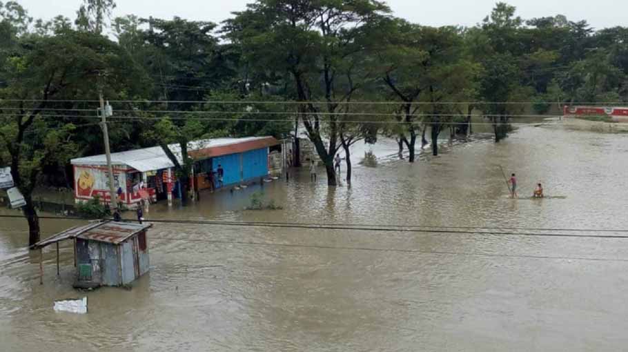
Sylhet and Sunamganj, two districts in the northeastern part of the country, are now experiencing the worst flooding in recorded history of 122 years, according to the Ministry of Disaster Management of Relief.
There have been three floods, including the current severe flooding, in three months this year in the two districts. The first flash flood hit the districts in early April, while the second flood hit in mid-May and the current flood began in mid-June which inundated 80 percent area of Sylhet district and 90 percent area of Sunamganj district.
Millions of people are facing untold suffering from the severe floods this year. The three devastating floods hit Sylhet and Sunamganj districts after highest rainfall in Cherrapunji in Meghalaya, adjacent to the two districts.
Cherapunji had received over 4000 mm of precipitation during the last ten days from June 10 to June 19. This amount of rain in such a short period is rare even for Cherrapunji, which is known as one of the most rain-prone regions in the world.
“This continuous and intense rain is mainly responsible for the floods in Sylhet region,” said Dr. Md. Khalequzzaman, Professor at the Department of Geology & Physics of Lock Haven University (USA).
Talking to Bangladesh Post yesterday, Monday, the Bangladesh-born US professor said that the Global Climate Change models have already predicted that the amount of rain and flood will increase over the next few decades.
So, it is apprehended that more severe floods, like the current massive floods, will hit Sylhet region and its adjacent areas in the coming days.
However, the catastrophic floods are not just due to the excessive rainfall in Cherrapunji. Flash floods are happening in Sylhet region as well as Meghalaya and Assam frequently also due to man-made causes.
Mostofa Kamal, a Phd researcher on weather and climate change at University of Saskatchewan in Canada, said that Cherrapunji receives some amount of rainfall almost every day during the monsoon due to its topography. However, the rainfall that has been falling in Cherrapunji since June 10 is unusually heavy, which later spreads to Sylhet region, causing severe flooding. However, the floods that hit Sylhet and Sunamganj this year have also man-made causes, he added.
According to him, “The cause is destruction of the natural forest on the hills of Meghalaya for commercial forestry or agriculture purposes. We can compare natural forests with thatched-house sheds. On the other hand, the hilly land, which was prepared for cultivation through destruction of natural forest, can be compared to a tin-house shed. It will take several times less time for the same amount of rain to fall from the thatched shed to the ground than for the tin-house. In fact, in the case of tin sheds, there is no chance of water freezing. As soon as it fell, it fell to the ground. This is exactly what has happened in recent years.”
Professor Khalequzzaman, however, also agreed with the observation, saying “Yes, this is correct. You can see this phenomenon in the border region in rivers that are flowing down from Meghalaya and elsewhere. Sand mining from rivers, agricultural practices, hill-cutting in Bangladesh, and unplanned urbanization are also contributing to the siltation problem in our rivers and in reduction of navigability.”
The expert on water, river and environment also said, “There was a major flood in the haor region in 2017. We have experienced floods in certain areas of Greater Sylhet and Mymensingh districts in 2018 and 2019. There have been three floods in three months in Sunamganj and Sylhet this year. The impact of flooding is intensified due to the reduction or decline in water-carrying capacity of rivers.”
The water-carrying capacity of the rivers flowing over Sylhet region, including Surma and Kushiayara, declined drastically due to siltation. Most of the rivers are silted up due to sediment deposition that comes from upstream regions in India and from within Bangladesh.
For this reason, the floodwater cannot flow to the Bay of Bengal easily. This is also a major factor for the terrible flood that Sylhet region is experiencing.
Professor Khalequzzaman said, “Some of our rivers lost navigability and water-carrying capacity in their certain segments and under major bridges, such as the Bhairab Bridge. This creates a prolonged water-logging in the haor region. These are responsible for the terrible flood that we are experiencing.”
Bhairab Railway Bridge was built in 1936. When the British built it on the Meghna, they contracted the width of the river and choked it during river training works.
Now there are three bridges on the same segment of the river instead of one. Two are rail bridges and another is the 1.2-road bridge, completed in 2002 that connects the Dhaka-Sylhet highway between Bhairab Bazar in Kishoreganj and Ashuganj in Brahmanbaria. The bridges are contributing to the contraction of the river. However, the river training techniques were not used properly in the latest two bridges. For this reason, the water level at the haor area permanently rose in the monsoon as natural drainage is affected. When a river flow is impeded, the natural process of siltation gets accelerated.
“The loss of navigability or reduction in water-carrying capacity at Bhairab Bridge is likely to contribute to stagnation of floodwater in the upstream haor region,” said Professor Dr Khalequzzaman.
Someone said that alongside the above mentioned reason, the 29.73-km road constructed in haor of Kishoreganj for smooth communication in three upazilas of the district is also responsible for flooding in Sylhet and Mymensingh regions. Most of the haors in Sunamganj and Sylhet districts are merged with haors in Kishoreganj as well as greater Mymensingh.
Water from incessant rain upstream in Meghalaya and Assam flows down to the Meghna River in Kishoreganj through rivers and haors in the Sylhet region. Many locals said the road in the middle hoar disrupts the free flow of water.
Alongside the destruction of the natural forest in Meghalaya hills, Mostafa Kamal also blamed the Austagram-Mithamaoin-Itna road, which is known as All-Weather Road, completed in 2020, for flooding in Sylhet region. This road has impeded the flow of upstream water into the rivers through the haor, he added.
“All-Weather Road is also a major obstacle to the normal flow of rain water and mountain slopes from the Meghalaya mountains. The rain-soaked silt or silt-laden water has been stagnant for three years due to the road through Kishoreganj haor. As a result, the navigability of rivers in haor areas has decreased. The rate of downstream water has also decreased due to the previous accumulation of water there,” said the researcher.
Mostafa Kamal also said, “The negative effects of this road are long-term. The construction of such a road in the haor area of Kishoreganj is tantamount to declaring war on nature. Whether the environmental survey was carried out before the road was built or whether the survey was carried out independently is a matter of considerable question.”
Professor Dr. A.K.M. Saiful Islam, director at Institute of Water and Flood Management of BUET, is not completely willing to blame the Austagram-Mithamaoin-Itna road for the severe floods in Sylhet region.
He thinks that the main reason behind this sudden flood is the heavy rainfall in Cherrapunji. “Global warming has changed the type of weather, climate or rainfall. Now when it rains, it rains much deeper. The Pacific also has a La Nino. That too has played a role in the heavy rains.”
“When it rains in Cherrapunji, it reaches Tahirpur of Sunamganj in six to eight hours. But the water is not able to come down quickly. As a result, it is spreading around and creating floods,” he added.
The BUET professor, however, said that unplanned construction of roads and embankments in haor is one of the reasons for the floods.
When asked about the impact of Austagram-Mithamoin-Itna road for severe flooding in Sylhet or Sunamganj, Professor Khalekuzzman said that such roads and embankments in haor can slow down the discharge of surface flow and can make floods worse.
Kasmir Reza, president of the Environment and Haor Development Organisation, said that the length of the drainage system of the road in the middle of the haor is only 900 metres, which is not sufficient for the flow of water. For this reason, the road is also responsible for frequent flash floods.
Meanwhile, no one from the Department of Bangladesh Haor & Wetlands Development of the Ministry of Water Resources, was available for comment in this regard.
Md Nurul Karim Bhuiyan, director (agriculture, water & environment) of the department, told this correspondent to talk to the director general of the department. However, Md. Mashuk Miah, director general of the department, could not be reached.
It can be said that not only the all-weather road of Kishoreganj, other roads and embankments in the haor area are also causing flooding problems. Such roads and embankments also bring negative impacts on environment, ecology and biodiversity.
Talking to Bangladesh Post, Mohammad Azaz, chairman at River and Delta Research Centre (RDRC), blamed the Joint Rivers Commission (JRC) for such severe flash flooding. Flood control measures in Bangladesh are limited, while the authorities concerned did not give a flood forecast, he added.
According to environmentalists and experts on water and river, Sylhet region is in dire straits due to some other reasons, including river navigability crisis, switch gates in haor, filling of haor and other water bodies, and indiscriminate cutting of hills.
The experts, however, spoke over a way-out. Md. Khalequzzaman said, “Due to climate change, flooding intensity and frequency are likely to increase in the future in Bangladesh. Water resources in all major rivers need to be managed on basin scale involving all co-riparian countries in the Ganges-Brahmaputra and Meghna (GBM) basins. The carrying capacity of rivers needs to be adjusted through capital dredging to facilitate unimpeded flow of flood waters to the Bay.”
He also suggested that flood forecasting systems need to be improved by considering hydrologic data from upper riparian countries. Only 8% of the GBM basins are located within the geographic territory of Bangladesh. An integrated water resources compact among all countries in the GBM basins will be necessary for flood mitigation, he added.
Some others also said that the solution is to dig up the two main rivers of Sylhet-- Surma and Kushiyara-- and other rivers and to dig out the natural rhymes flowing through the Sylhet city. This will ensure normal flow of water.
Abdul Hye Al-Hadi, an environmental activist from Sylhet, said that well-planned dredging is one thing that must be started soon in the rivers of Sylhet.
Mostafa Kamal said that the issue of destruction of forests and hills in Sylhet region should also be kept in mind here. As a result, there is no alternative to increasing the navigability of the major rivers of Sylhet by dredging every year.
He said, “Since man has not yet acquired the ability to control nature; natural disasters cannot be prevented. However, it is possible to reduce the risk of natural disasters by using human acquired knowledge. For example, if it is possible to reach people two weeks before with a relatively accurate weather forecast of a natural disaster, the loss of life and property can be greatly reduced. That is what is being done worldwide.”